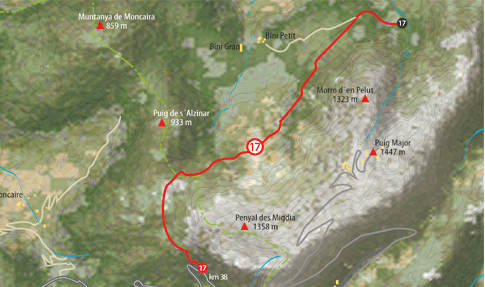
It constitutes one of the simplest routes and yet the most spectacular as it all runs down the north face of Puig Major with impossible cliffs which sheer down towards the sea. The Camí des Cinglesrefers precisely to the cliffs (cingles) which tower over this Alpine landscape. From Sóller we have to take the C-710 road in the direction of Puig Major until attaining km 38.1 where we can leave the car in a small parking area alongside the road. From here we have to take the path which links the road to the estates of Bini Petit and Bini Gran; there should be no problem finding the access. The route starts with a small ascent of around 30 metres, arriving at a green crossing gate which we can pass on its left If it Is closed. Shortly after going over the first crossing gate, we will run into another (you must always leave the crossing gates closed if they were like that when you found them). If you go on this excursion in summer it is worth remembering that the heat around these places is suffocating and the fountains are dry. Once we get onto the path we can behold on our right the impressive block of Penyal des Migdia which will accompany us for a good part of the route. We will gently begin to ascend between the trees until arriving at Coll des Cardscolers where the mountain clears and we can delight in the view of a marvellous landscape; from here we can see on our right the radar stations located on top of Puig Major (1,455 metres), the highest peak in Majorca. |
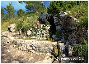
If we turn our gazes left we can behold a cross-shaped monument and behind it a small hillock; if we decide to go up it (highly recommended), we can delight in some excellent views over the Montcaire Mountain and the hill of Sa Vacade la Calobra. Retracing our steps, we continue on the path until coming to the valley of Bini where we will find the settlements of Bini Petit and Bini Gran. Once we have passed the hamlets there is a path which leads us to Sa Coma Fosca, but before we run into the Fountain of Sa Bauma, situated under an immense, solitary, old black poplar. The paths starts turning into a trail and from this point onwards we start a gentle descent, delighting in a view of the immense slope which comes down from the summit of Puig Major. After a few minutes of the route we reach a lighting tower where we can recharge our batteries before commencing the return journey. |
|
||||||||||||
|
||||||||||||||
 Download
 See Description of the Route |
||||||
 |
||||||
|
||||
|
||||