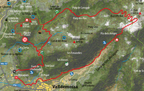
One of the most popular routes amongst the people of Majorca is the ascent to the massif of Puig del Teix via the Archduke path, an extraordinary dry stone path built by Archduke Luis Salvador of Austria. Said route goes along one of the most daring, spectacular stone paths conserved on the island. The route consists of the ascent to Teix via the path which crosses Pla des Pouet and rises to the vantage point of Ses Puntes where the Archduke built an amazing stone balcony over the coast. The best reference for finding the path which goes up to Pla des Pouet is to locate the State school situated on the higher part of the village. reaching the population from Palma via the C-710 road, the road can be ascended via the street which starts at the first traffic lights. Upon reaching the first crossroads, the wrought iron gate of the school appears opposite, very easy to locate thanks to the stone arches which close the main façade. Slightly higher we take Calle Oliveres, going up till the end, where a fence prevents us from passing. Alongside the fence on the left a well-marked path appears. On the gate there is a small wooden sign telling us the direction to follow (Teix). After five minutes we cross a narrow pass which takes us into a dense oak wood with the remains of coal-mining activity. The path which goes up to Pla des Pouet is an old high road with the remains of the original cobbles and a winding route to make up for the steepness of the hillside. The most difficult area is to be found in the first part of the ascent where there are several charcoal ruins near the S´Abeurada fountain on the left of the main path. Once this spot has been passed, it is best to carry on via the dry stone path until the entrance to Pla des Pouet. A pla is a strip of forest which conserves the purest essence of the Balearic Mediterranean forest. Having reached this point, we will have covered the first 270 metres of the slop. A passage without any barrier opened in a wall indicates the entrance to the plain. Opposite, and passing alongside a well, the path starts which takes us, after a hard ascent, to the vantage point of Ses Puntes, a beautiful stone balcony over the Mediterranean. The path winds via a vegetal tunnel of twisted holm oaks, strawberry trees, buckthorn and mastic. After reaching the vantage point it is inevitable to stop to behold such a lavish landscape for a few minutes, also taking a few minutes to recharge our batteries. |
From here onwards, we enter the most spectacular part of the route, passing via a small shelter in ruins and then overcoming a modest summit. The path runs on a cornice of amazing sea views, almost 900 metres below. We enter the area known as Racó Perdut. Here, a large stone milestone tells us that we must leave this track and take a well-marked path on the left which leads us to our goal. The path is not too good, but it is not particularly difficult. First you have to undertake a short climb, no sooner than starting the ascent, then following through scrubland until the plateau of Pla de Sa Serpe. The path crosses the plain and goes up to the pass which separates the peaks of Teix and Teixot, with the ascent ending via a very rocky area. The descent from the peak is made via the same route which again links up to the Archduke Path at Racó Perdut (Lost Spot). The dry stone path follows a rapid descent via Sa Coma de Cairats and arrives at Pou de Sa Neu (Snow Well) of Son Moragues. Alongside there is a mountain shelter built on the remains of the former outbuildings called nevaters or snow harvesters' huts. The route continues downward via the forest trail, passing through a recreational area (Ses Moragues) |
|
||||||||||||
|
||||||||||||||
 Download
 See Description of the Route |
||||||
 |
||||||
|
||||
|
||||